Friday, September 11, 2015

Volcanic 50 – Circumnavigation of a Topless Lady


“First I must tell you that I count it no small wonder to be alive.”  Thus began the captivating account in National Geographic Magazine of what happened to this mountain the morning of May 18, 1980.  I was 13 years old, spellbound by Rowe Findley’s narrative of the largest volcanic eruption in the history of the United States, in which Mount Saint Helens lost her top, and 57 people lost their lives.  So spellbound in fact, that despite my limited command of English, I worked myself through the entire report more than once.  It was likely the first full-length English-language article in a major magazine I ever read.

Mount Saint Helens, the "Lady of Fire", was 5,500 miles away from my hometown in Austria and yet I knew right then that someday I would travel all the way to Washington State and the Cascade Mountains to bear witness to the magnificent forces nature had set free.

That day finally came last week, when, 35 years, three months, and 19 days after that fateful morning in 1980, I found myself at the starting line of the Volcanic 50, an ultra-marathon around the very mountain that was now missing its top.

The atmosphere at the race start brimmed with anticipation as runners imagined the challenging day ahead.  There was a palpable tension tinged with excitement – almost as if the mountain were about to stir once again.  But before I knew it, the race was underway.  “This is it”, I thought, remembering that those were the last words of geologist David Johnston, radioed to the US Geological Survey on May 18 at 8:32am, announcing the start of the cataclysmic event.

The tension dissipated quickly as soon as everyone was on the trail. A long conga line formed heading into the clouds.

After a gradual incline along a spur trail the course joined the Loowit trail, a rocky and rugged single-track that circumnavigated the entire mountain.

The climbing began in earnest.  I could briefly see a flank of the mountain in a window between the clouds but soon the gap closed and the trail was once again cloaked in mist.

Thick fog clang to the rocks as I reached the first boulder field.  It was a surreal sight. Massive rocks were piled on top of each other. A few forlorn tree-skeletons miraculously remained standing amidst all the destruction as a group of ghostly “runners” gingerly picked paths across this desolate wilderness.

After a while the fog lifted but the difficult footing continued.  Rays of sunlight streamed through the clouds, opening views across the slope.  Fitting the scene, the tree-skeletons were gone and replaced by young fir trees wondrously growing right out of the rocks.

Eventually, rocks gave way to sand and softly padded wooden soil – a trail runner’s delight!  However, the forested sections harbored an unexpected hazard of a different kind: aggressive ground wasps.  I was usually alerted to their proximity by shrieks of runners getting stung on the trail ahead of me.  Some runners were hit hard with one of them getting stung as many as 17 times.  I don’t know if the wasps didn’t like me or if I just got lucky, but if it had not been for the shrieks, I would not even have noticed them.

The next obstacle was the crossing of the Toutle River just after the second aid station.

My hiking poles aided me in some minor rock-hopping acrobatics to get across the river without soaking my shoes.  I was thankful because my feet are prone to blister when wet.


The climb out of the riverbed was steep, sandy, and slippery but a rope – which we were warned not to rely upon – assisted the scramble.

Colorful views of the Toutle River Valley opened up just before the trail climbed once again into the clouds.

Traversing a steep and barren pumice field, I felt wholly immersed in the desolate wilderness as I headed deeper into the blast zone.

The blast zone is an area north of the volcano that was completely flattened within seconds after the volcano’s eruption.  The blast’s velocity reached speeds of up to 670 miles per hour, just shy of the speed of sound.  Rock, ash, and hot gases racing away from the mountain devastated an area of about 230 square miles. The blast was widely heard hundreds of miles away in the Pacific Northwest, including parts of British Columbia, Montana, Idaho, and northern California.

35 years after the explosion life has returned to the blast zone.  I found the area dotted with grasses, shrubs, and several species of wild flowers.

The trail’s name, Loowit, was also the native Indian’s name of the volcano itself.  Loowit is short for Loowitlatkla, literally meaning “Lady of Fire” in the language of the local Puyallup Indians.  Legend has it that Loowit had been a wrinkled old woman, who tended a fire burning at the center of a natural stone arch spanning across the raging Columbia River.  The arch was named Tamanawas Bridge, “Bridge of the Gods.”

One day, the great chief Tyee Sahale wanted to reward Loowit for her faithful service by bestowing upon her eternal life.  Loowit was devastated that she would have to live forever as an old hag and so the chief granted her wish to be young and beautiful. This made her the subject of great attention.  Unfortunately, the chief’s own sons, Wyeast and Klickitat, both fell in love with her.  Unable to choose between them, the sons had a tremendous fight over her, burning down forests and villages.

The colossal destruction made the great chief so angry that he destroyed the bridge and smote the three lovers.  Where each lover fell, he raised up a mighty mountain. Because Loowit was beautiful her mountain (St. Helens) was a symmetrical cone, dazzling white. Wyeast's mountain (Mount Hood) still lifts his head in pride. Klickitat, despite his rough ways, had a tender heart.  As Mount Adams, he bends his head in sorrow, weeping to see the beautiful maiden Loowit wrapped in snow.

An area called “the Breach” offered the most spectacular reminders of the power that was unleashed by the explosion and subsequent landslide, the largest debris-avalanche recorded in historic times.  The avalanche moved downslope at speeds of 110 to 155 miles per hour.  Part of it surged into and across Spirit Lake eventually raising the lake’s bottom by 300 feet and the water surface by 200 feet.  4 miles north of the summit, the front of the avalanche still had sufficient momentum to flow over a ridge more than 1,150 feet high.  The elevation of the mountain's summit was reduced from 9,677 feet (2,950 m) to 8,363 feet (2,549 m), replacing it with a 1-mile wide horseshoe-shaped crater.

As I passed through the blast zone I continued to glance to my right, towards the top of the mountain. It had remained stubbornly hidden among the clouds, when, suddenly, if only for 10-15 seconds, the clouds lifted enough for the summit to come into view. High on the slope I even spotted a herd of mountain goats.
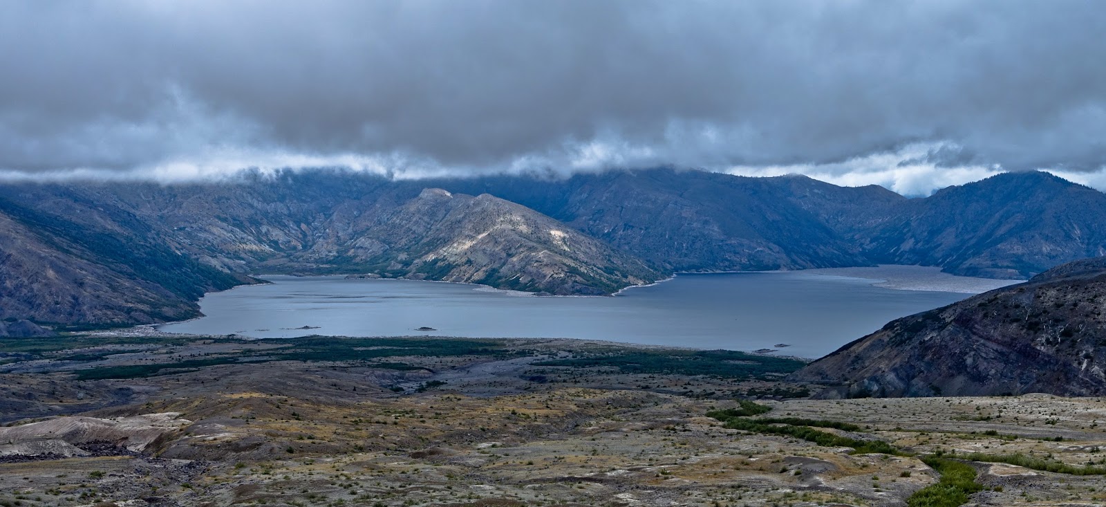
The trail continued to ascend and views of Spirit Lake opened up to my left.  I could see tens of thousands of trees that were felled 35 years ago still floating on the surface in the lake’s distant northeastern corner.
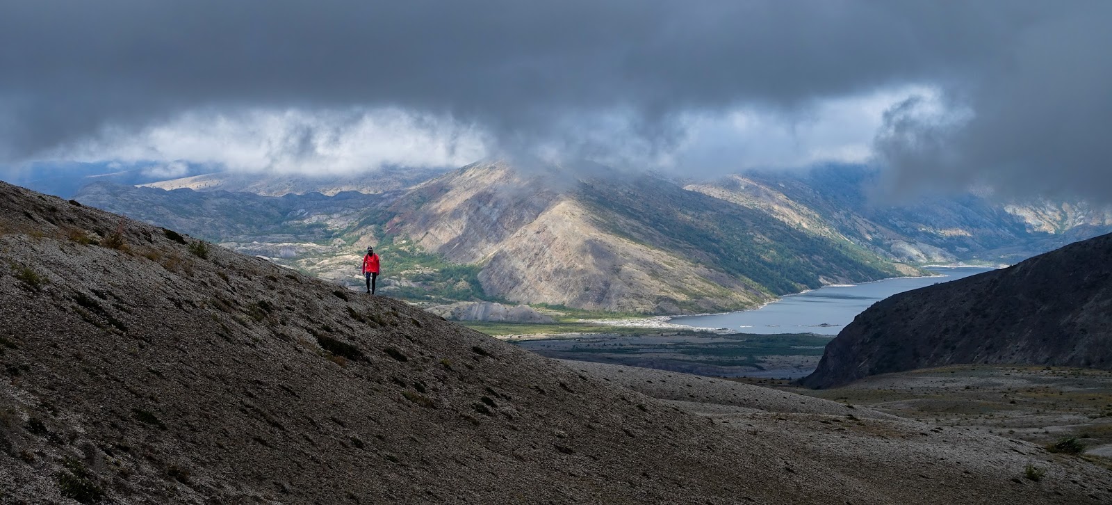
Amidst all the sightseeing and picture taking I almost forgot that I was actually in a race.  As I left aid station three and climbed over Windy Ridge I remembered the 9-hour cutoff at aid station four.


Some quick math revealed that I was in no danger of missing the cutoff and so I decided to continue at my leisurely pace without regards for my standing in the race.

The next part of the trail led me down into the Plains of Abraham, a flat expanse of barren, ash-strewn meadows that is only just beginning to recover from the devastation wrought by the eruption.

On the south side the plains gave way to a sharp drop into a steep canyon, while the trail skirted along the rim before gradually dropping to the last aid station.

Each of the four aid stations was extremely well stocked and organized despite the fact that none was accessible by motorized vehicle.  The amazing volunteers had carried all the food and drinks for more than 200 runners over steep and technical terrain for several miles up the slopes of the mountain.  They were the true athletes of this race and their positive attitude was both infectious and astounding.

The clouds dropped lower and light rain began to fall as I continued along the steep eastern slope of the volcano.

Streams had dug deep gullies into the loose, colorful, and mineral-laden soil.

Shortly before the trail dropped back down into the woods, the sun broke through and a rainbow stretched across the valley.

Close to the end of the loop on the south side the trail crossed another boulder field before finally reaching the soft forest track of the spur trail towards the finish.  I had another 2 ½ miles to go but running on the graded downhill path was sublime. With the mountain views behind me, I clocked my fastest pace of the entire race, passing several other runners on the way.

All in all I spent 10 hours and 44 minutes out on the 54km course, much longer than on any of my other 50ks.  I enjoyed every minute, grateful that I was able to see and experience the mountain myself and marvel at the magnificent forces that nature had unleashed.

Tuesday, August 4, 2015

Tushar Sky Marathon - Mountains of Hope

“Can you please say something hopeful?” Those were the desperate words of a fellow runner after race director Matt Gunn finished the pre-race briefing. During his talk, which ran longer than usual, Matt apologized that the course was “a lot more technical than I remembered”. “There’s a lot of scrambling, the trail is overgrown, and there are a lot of loose rocks.” Matt also sounded concerned about the trail markings as they “tend to disappear”. After all, there were cows, mountain goats, and elk and it seems “they all get to them”. Just the previous night, Matt himself, who knew the mountains better than anyone else around, had got lost while checking on the trail markings, finally returning at 8AM, six hours later than planned. His right hand man, Turd’l, had almost launched a search and rescue operation. There was also the threat of thunderstorms, “a regular occurrence in the afternoon”, Matt explained. The course followed exposed ridges far above the tree line, not a place anyone would want to be during a lightning storm. “I suggest you bring a hat”, Turd’l helpfully offered. And “you’re all going to do great”, which were the most hopeful words we were going to get. “This is going to be amazing”, someone said, deeply in awe.

Race Director Matt Gunn at the pre-race briefing

The race offered three distances. A half-marathon, a full marathon, and a 93 km ultra. I had initially contemplated the full 93km distance but after the race briefing I understood how foolish this would have been. Having landed in Salt Lake City the morning before the race, Gudrun and I reached the high elevations of the Tushar Mountains just after 3PM. A short hike already left me out of breath. We were, after all, sea-level dwellers who now found ourselves at an altitude above 10,000 feet (3,000 meters). There was no time to adjust to the thin air before the run, and the threat of altitude sickness was a real concern. Suddenly even the marathon distance seemed a daunting endeavor.

Casual countdown before the start

I slept poorly the night before the race. Maybe I should not have googled the symptoms of altitude sickness? Trouble sleeping was one of them. While I lay awake, I was contemplating the other symptoms: light-headedness, headache, feeling weak and tired, nausea and vomiting. I didn’t think I had any of those. Or did I? When I tried to focus my mind on other things I inadvertently started to ponder the other threats: getting lost, getting injured, and, the scariest of them all, getting struck by lightning.

Initial climb along the slopes of Mount Holly

The morning air was fresh and cool as I arrived at the start 15 minutes before 7 AM. A handful of runners were milling around and others were trickling in. I was thinking of the 93 km runners who had started under a Blue Moon and were already on the course for the past two hours. Then Matt Gunn arrived just in time to send us on our way.


Approaching the first ridge of the day

A short section along the ski slope spread out the field and I found myself towards the rear of the pack as we entered the back-country on a narrow single-track that immediately began to climb, skirting along the side of Mount Holly, and heading towards the morning sun, still hidden behind the ridges.

Above the tree line on the approach to the second ridge

Reaching 11,300 feet

Stunning views across a wide and forlorn valley opened up on the back of Mount Holly when the trail reached the second ridge, topping out at 11,300 feet.

Mineral-rich mountain slopes on the other side of Cottonwood Canyon

From there the trail dropped steeply below the tree line and into the bottom of Cottonwood Canyon, about a thousand feet below.

Steep descent into Cottonwood Canyon

Purple-colored lava rocks dotted with wildflowers characterized the slopes. The Tushars originally arose through volcanic activity between 22 and 32 million years ago. The current peaks had been formed by a gigantic explosion that blew off the top of a massive mountain. Fortunately, this was a long time ago, so I did not have to add volcanic eruptions to my list of potential threats.


Colorful slopes in Cottonwood Canyon

A steep climb along a washed out double track led to the top of Alunite Ridge from where the course dropped in a series of switchbacks into Bullion Canyon.


View into Bullion Canyon

Abandoned mining huts were the remnants of a large gold mining community that populated the area in the late 19th century. More than 1,600 people lived in this high and inaccessible mountain valley at the height of the gold rush around 1880. Most of the early miners were single – prospectors and adventurers who came here with often misplaced hopes for sudden riches. The combination of guns, whiskey, and gambling made for an explosive social environment that earned this valley the description as one of the “wildest and woolliest places on earth.” (A History of Bullion Canyon by Daniel Glass)

Remnants of mining huts in Bullion Canyon

My race was going quite well up to this point. I had made good time until the first aid station just before Alunite Ridge, and I had passed several runners on the downhill section into Bullion Canyon. But then came the brutal part of the course: a steep 2,000 foot climb up to Delano Peak, the highest point in the Tushar Mountains at 12,173 feet (3,710 meters). 

In one of the valleys

The climb started easy enough as I tiptoed along a creek bed to keep my feet dry. But after a while I noticed that I had not seen any trail markings for some time and began to wonder if I was still on the right track. I stopped for a moment to look for pink flags wondering whether to turn around. I was at the bottom of a narrow valley and there seemed to be no other place to go. There were fresh-looking footprints on the trail and I noticed that many wildflowers along the path had recently been trodden on. So I continued, still hopeful, albeit with some trepidation. After a few creek crossings I reached another mining hut, and still, there was no pink flag to be seen.

Flying down into Bullion Canyon
 

Slowly, I walked onwards another few hundred yards. Where were the runners who I had passed on the downhill section? Surely they would be here by now. I suddenly felt lost. I remembered Matt Gunn warning us that the Forest Service made him pick a route that climbed straight up the slope where there was no discernable trail. Had I missed the fork?

Searching for pink flags on the climb out of Bullion Canyon

Eventually, I turned around. If nobody was coming up behind me that would be a sure sign that I had gotten off route. A few minutes later I was back at the mining hut when I saw a group of three runners approaching around a bend from below. They looked lost as well, asking me if I had seen any flags. I stopped to wait for them. And then, right next to me, I spotted the remnants of a pink tape on the ground amidst a bunch of wild flowers. We were all relieved. I picked the tape up and tied it to a nearby bush so it would once again be visible. Why had it been on the ground? Had it been chewed upon? I could not tell. At least we were still on the right track, our hope still alive.


There is no discernible trail. But there are flags ahead. So the fun can continue.

A little further on the trail turned to the right, still following the contours of the valley. This is when I spotted another pink flag on the steep slope to my left. This must have been the point Matt warned us about. We scrambled up the slope, climbing from one flag to the next. Fortunately, none of these markers had been eaten!


Relentless climbing continues


Reaching the tree line.  "This looks like a great place to die," jokes Cory Reese.

As we reached the top of the tree line the valley opened up and revealed the steep east slope of Mount Delano right in front of us. Wow!

A short reprieve, then it's another 1,000 feet to the top

Soon my pace dropped to not much more than that of a crawl. I inched along, step by step, slowly putting one foot in front of the other. My legs felt fine but whenever I tried to move faster in the thin air, my heart seemed to beat right out of my chest.

Across the plateau between Mount Delano and Mount Holly

The final two kilometers to the top of the Tushar Mountains took me more than an hour. It was the slowest I had ever moved in any race. When I finally reached the summit, I could not believe that I had outpaced my companions, who were still one or two hundred feet below.

Final climb to the top of Mount Delano

The top offered views across the entire Tushar mountain range and into the valleys beneath.

View across the Tushars from the top of Mount Delano

Mount Belknap, the most prominent peak of the Tushars and just 60 feet lower than Mount Delano, has retained the typical cone shape of a stratovolcano characterized by gentle lower slopes and gradually steeper-pitched upper inclines. I took a few minutes to relish the moment, catch my breath, and sign the summit register.

View into Bullion Canyon from Mount Delano

The track down the other side seemed a little less steep but it was fairly technical and I carefully watched my footing to not roll an ankle.

View across the plateau - Mount Baldy and Mount Belknap are in the background

I lost more than 1,300 feet (400 meters) in 20 minutes before arriving at a dirt road that began to climb anew. I finally reached Mud Lake Aid Station after almost 6 hours, only 16 miles into the race. I had four hours left to cover the remaining 10 miles before the race cutoff. Surely this would be enough. Or would it? My hope was still alive.

Panorama on the eastern side of Delano Peak

A German speaking aid station volunteer stuffed me with pan-cakes, soda, and candy, kindly replenished my hydration pack, and put me back on the course a few minutes later.

After a short climb, a relatively smooth and well-graded downhill track dropped 1,400 feet over the next 3 miles. Although my legs were tired, and my shoes rubbed against my ankles on the off-camber trail, I managed to clock my fastest split times during this section until bottoming out at the lowest point of the course at 9,600 feet.

Narrow but well graded single track on the descent from Mud Lake.

A tedious 1,000 foot climb along a forest road led to the last aid station where I caught up with two other runners who had outpaced me on the climb. I tried to keep up with them as the trail continued to climb another 400 feet but soon they were once again ahead of me and out of sight.

The following two miles were the only section of the entire course that was more or less flat. However, the trail was quite technical, making running difficult.


One mile before the end, I found myself back on the spur trail leading to the finish line. I was able to pick up the pace, resolved to finish strong. Just after entering the ski area I once again passed the two runners who had left me behind on the climb a few miles back. A final push up the last hill took me to the finish line after 9 hours and 25 minutes.

I was astonished to find out that despite my incredibly slow pace I managed to stay ahead of one third of the field landing in 30th place out of 45 participants. Even though this was “just a marathon”, the altitude, the steep climbs, and the difficult trails made it one of my most demanding races to date. The incredible scenery made all the effort worthwhile and thankfully, no one got seriously injured, no one got lost, and we did not run into any lightning storms. All 45 runners were able to finish the race.  Hope, it turns out, was strong enough to keep everyone going until the end. And that in itself is something hopeful indeed.