“First I must tell you that I count it no small wonder to be
alive.” Thus began the captivating account in National Geographic
Magazine of what happened to this mountain the morning of May 18, 1980. I
was 13 years old, spellbound by Rowe Findley’s narrative of the largest volcanic
eruption in the history of the United States, in which Mount Saint Helens lost
her top, and 57 people lost their lives. So spellbound in fact, that
despite my limited command of English, I worked myself through the
entire report more than once. It was
likely the first full-length English-language article in a major magazine I
ever read.
Mount Saint Helens, the "Lady of Fire", was 5,500 miles away from my hometown in
Austria and yet I knew right then that someday I would travel all the way to
Washington State and the Cascade Mountains to bear witness to the magnificent
forces nature had set free.
That day finally came last week, when, 35 years, three months,
and 19 days after that fateful morning in 1980, I found myself at the starting
line of the Volcanic 50, an ultra-marathon around the very mountain that was
now missing its top.
The atmosphere at the race start brimmed with anticipation as
runners imagined the challenging day ahead. There was a palpable tension
tinged with excitement – almost as if the mountain were about to stir once again.
But before I knew it, the race was underway. “This is it”, I thought,
remembering that those were the last words of geologist David Johnston, radioed
to the US Geological Survey on May 18 at 8:32am, announcing the start of the
cataclysmic event.
The tension dissipated quickly as soon as everyone was on the
trail. A long conga line formed heading into the clouds.
After a gradual
incline along a spur trail the course joined the Loowit trail, a rocky and
rugged single-track that circumnavigated the entire mountain.
The climbing began in earnest. I could briefly see a flank
of the mountain in a window between the clouds but soon the gap closed and the trail
was once again cloaked in mist.
Thick fog clang to the rocks as I reached the first boulder
field. It was a surreal sight. Massive rocks were piled on top of each
other. A few forlorn tree-skeletons miraculously remained standing amidst all
the destruction as a group of ghostly “runners” gingerly picked paths across
this desolate wilderness.
After a while the fog lifted but the difficult footing continued.
Rays of sunlight streamed through the clouds, opening views across the
slope. Fitting the scene, the tree-skeletons were gone and replaced by
young fir trees wondrously growing right out of the rocks.
Eventually, rocks gave way to sand and softly padded wooden soil
– a trail runner’s delight! However, the forested sections harbored an
unexpected hazard of a different kind: aggressive ground wasps. I was
usually alerted to their proximity by shrieks of runners getting stung on the
trail ahead of me. Some runners were hit hard with one of them getting
stung as many as 17 times. I don’t know if the wasps didn’t like me or if
I just got lucky, but if it had not been for the shrieks, I would not even have
noticed them.
The next obstacle was the crossing of the Toutle River just
after the second aid station.
My hiking poles aided me in some minor
rock-hopping acrobatics to get across the river without soaking my shoes.
I was thankful because my feet are prone to blister when wet.
The climb out of the riverbed was steep, sandy, and slippery but
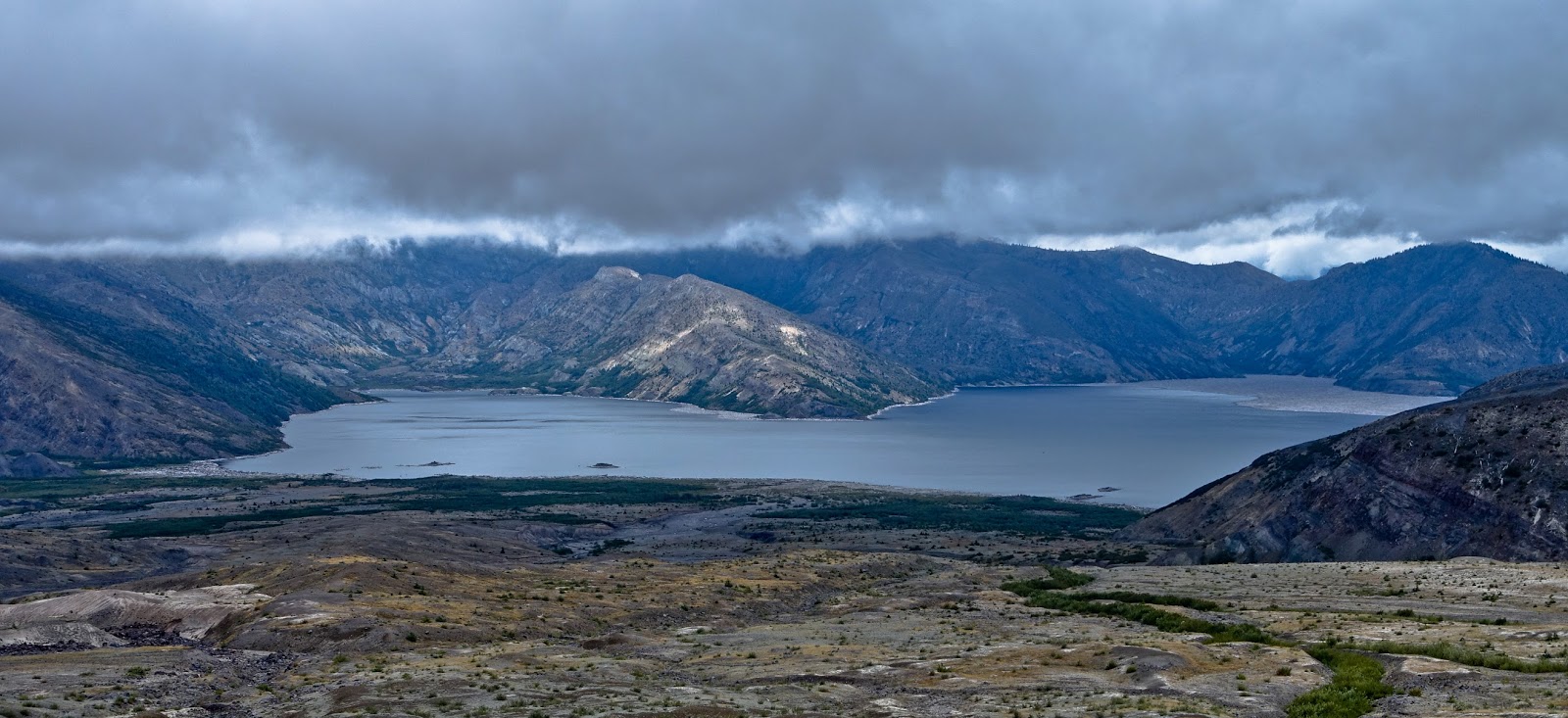
a rope – which we were warned not to rely upon – assisted the scramble.
Colorful views of the Toutle River Valley opened up just
before the trail climbed once again into the clouds.
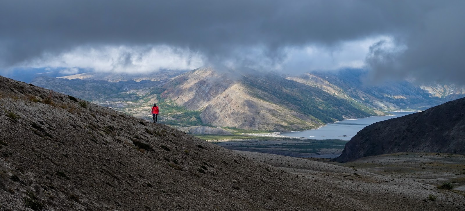
Traversing a steep and barren pumice field, I felt wholly
immersed in the desolate wilderness as I headed deeper into the blast zone.
The blast zone is an area north of the volcano that was
completely flattened within seconds after the volcano’s eruption. The
blast’s velocity reached speeds of up to 670 miles per hour, just shy of the
speed of sound. Rock, ash, and hot gases racing away from the mountain devastated
an area of about 230 square miles. The blast was widely heard hundreds of miles
away in the Pacific Northwest, including parts of British Columbia, Montana,
Idaho, and northern California.
35 years after the explosion life has returned to the blast zone.
I found the area dotted with grasses, shrubs, and several species of wild
flowers.
The trail’s name, Loowit, was also the native Indian’s name of
the volcano itself. Loowit is short for
Loowitlatkla, literally meaning “Lady of Fire” in the language of the local
Puyallup Indians. Legend has it that Loowit had
been a wrinkled old woman, who tended a fire burning at the center of a natural
stone arch spanning across the raging Columbia River. The arch was named
Tamanawas Bridge, “Bridge of the Gods.”
One day, the great chief Tyee Sahale wanted to reward Loowit for
her faithful service by bestowing upon her eternal life. Loowit was
devastated that she would have to live forever as an old hag and so the chief
granted her wish to be young and beautiful. This made her the subject of great
attention. Unfortunately, the chief’s own sons, Wyeast and Klickitat,
both fell in love with her. Unable to choose between them, the sons had a
tremendous fight over her, burning down forests and villages.
The colossal destruction made the great chief so angry that he
destroyed the bridge and smote the three lovers. Where each lover fell,
he raised up a mighty mountain. Because Loowit was beautiful her mountain (St.
Helens) was a symmetrical cone, dazzling white. Wyeast's mountain (Mount Hood)
still lifts his head in pride. Klickitat, despite his rough ways, had a tender
heart. As Mount Adams, he bends his head in sorrow, weeping to see the
beautiful maiden Loowit wrapped in snow.

An area called “the Breach” offered the most spectacular
reminders of the power that was unleashed by the explosion and subsequent
landslide, the largest debris-avalanche recorded in historic times. The
avalanche moved downslope at speeds of 110 to 155 miles per hour. Part of
it surged into and across Spirit Lake eventually raising the lake’s bottom by
300 feet and the water surface by 200 feet. 4 miles north of the summit,
the front of the avalanche still had sufficient momentum to flow over a ridge
more than 1,150 feet high. The elevation of the mountain's summit was
reduced from 9,677 feet (2,950 m) to 8,363 feet (2,549 m), replacing it with a
1-mile wide horseshoe-shaped crater.

As I passed through the blast zone I continued to glance to my right, towards the top of the mountain. It had remained stubbornly hidden among the clouds, when, suddenly, if only for 10-15 seconds, the clouds lifted
enough for the summit to come into view. High on the slope I even spotted a herd of mountain goats.
The trail continued to ascend and views of Spirit Lake
opened up to my left. I could see tens of thousands of trees that were
felled 35 years ago still floating on the surface in the lake’s distant northeastern
corner.
Amidst all the sightseeing and picture taking I almost forgot
that I was actually in a race. As I left aid station three and climbed over
Windy Ridge I remembered the 9-hour cutoff at aid station four.
Some
quick math revealed that I was in no danger of missing the cutoff and so I
decided to continue at my leisurely pace without regards for my standing in the
race.
The next part of the trail led me down into the Plains of
Abraham, a flat expanse of barren, ash-strewn meadows that is only just
beginning to recover from the devastation wrought by the eruption.
On the south side the plains gave way to a
sharp drop into a steep canyon, while the trail skirted along the rim before
gradually dropping to the last aid station.
Each of the four aid stations was extremely well stocked and
organized despite the fact that none was accessible by motorized vehicle. The amazing volunteers had carried all the
food and drinks for more than 200 runners over steep and technical terrain for
several miles up the slopes of the mountain.
They were the true athletes of this race and their positive attitude was both infectious and astounding.
The clouds dropped lower and light rain began to fall as I
continued along the steep eastern slope of the volcano.
Streams had dug deep gullies into the loose,
colorful, and mineral-laden soil.
Shortly before the trail dropped back down into the woods, the
sun broke through and a rainbow stretched across the valley.
Close to the end of the loop on the south side the trail crossed
another boulder field before finally reaching the soft forest track of the spur
trail towards the finish. I had another
2 ½ miles to go but running on the graded downhill path was sublime. With
the mountain views behind me, I clocked my fastest pace of the entire race, passing several other runners on the way.
All
in all I spent 10 hours and 44 minutes out on the 54km course, much longer than
on any of my other 50ks. I enjoyed every
minute, grateful that I was able to see and experience the mountain myself and
marvel at the magnificent forces that nature had unleashed.