
When Mormon settlers reached the awe-inspiring canyons
around the fertile Virgin River in Southern Utah, they declared their search
for a new homeland complete. According to “Utah: A Guide to the State”, Native
Americans living in the area avoided the dark canyons, and thus the valley
offered a sanctuary for the settlers. Drawing analogies from another wandering
people in biblical times, they named the canyons surrounded by towering red
rock formations, Little Zion.
According to Wikipedia, the word Zion first appeared in the
Book of Samuel, dating from the 6th century BCE. It commonly refers to the geographic area of
Jerusalem, but also to "the World to Come", the Jewish understanding
of the hereafter. Others have adopted
Zion as a metaphor, symbolizing a longing by wandering peoples for a safe
homeland. And for some, it has taken on a more spiritual meaning—a peace of
mind in one's present life.
(When Brigham Young, the founder of the Mormon Church, later
visited the area, he admonished the settlers that this was, in fact, at least
in his opinion, not Zion. So, for a
brief period, his faithful disciples changed the name to “Not Zion”. However, ultimately neither “Not” nor
“Little” stuck, and so, Zion it was.)
On April 9, Gudrun and I headed to Zion Canyon where I
joined a few hundred other intrepid souls who had signed up for the Zion 100, for their own wandering journey in this the area.
The Zion 100 is an ultra-marathon footrace through the surrounding
desert, up and over slick-rock covered mesas, until, many long hours later, it
ends back at the start in the small village of Virgin, Utah.
 |
| Pre-race briefing by race director Matt Gunn and his team, the evening before the race |
 |
| 5:50AM, just before the start of the race in Virgin, Utah |
As always, the reasons for participating in these kinds of
adventures are as diverse as the participants themselves. For some it is simply an opportunity to run
in beautiful places, to do what they love to do. For others it is an opportunity to challenge themselves,
to test their physical and mental endurance. And for some it may indeed be
something more akin to a personal quest for meaning, an expression of their own
longing, even perhaps, their own search for Zion.
 |
| The race is on |
These thoughts were on my mind as I headed out on the course
at six o’clock in the morning. It was
pitch black as I trekked along amidst a long line of runners following a soft
and sandy double-track trail illuminated by a string of headlamps.
 |
| The first little hill |
A few miles into the course, the terrain became hilly and the
trail began to climb towards our first destination: Flying Monkey Mesa.
Mesa is the Spanish word for table and so my mind conjured
an image of a table surrounded by Flying Monkeys. But that did not make a lot of sense. Why wouldn’t the monkeys sit at the
table? What were flying monkeys
anyway? And what were they doing in the
desert? As far as I was aware, there
were no monkeys in Southern Utah to begin with, let alone flying ones.
 |
| Ascending in twilight before dawn |
The mesa part of the story was easy enough to figure out. Of course the word mesa is the common American
term for tableland, an elevated area of land with a flat top and steep cliffs. Mesas form by erosion of horizontally layered
rocks that have been uplifted by tectonic activity. The weaker types of rocks are eroded away over
time, leaving the more resistant types of rocks topographically higher than
their surroundings.
 |
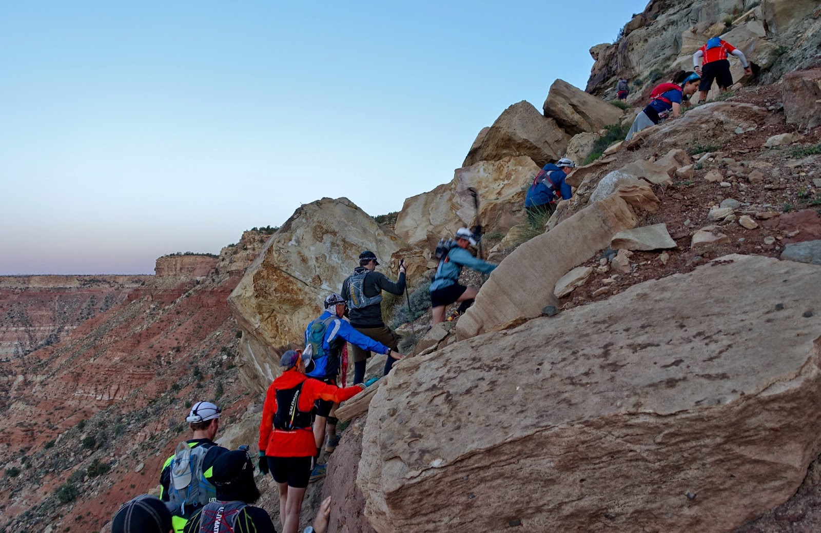
| You can follow the string of headlamps all the way to the top |
Gradually, dawn broke as we were conquering the cliffs
offering the first great views over the Virgin River Valley.
 |
| View towards Hurricane, the village of Virgin is on the left |
And yes, the cliffs were steep.
 |
| Conga-line before a bit of scrambling, a rope offered assistance |
The first rays of the sun hit the valley as I got close to
the top of the first mesa of the day.
 |
| Deep red colors across the valley. Gooseberry Mesa, the third mesa of the day, is to the left in the distance |
At the top, the course had us running around the mesa in a
big 6-mile circle. It dawned on me that
perhaps we were the monkeys. Although,
after all the climbing, I can hardly say we were flying.
 |
| Running atop Flying Monkey Mesa |
The trail was glowing in the soft morning light. Wherever the monkeys were, I’m sure they
enjoyed the views.
 |
| Rolling hills on the east side of Flying Monkey Mesa |
The forest atop the mesa did look like it could provide a
good habitat for monkeys.
Wait, is this real?
 |
| Monkey habitat? |
OK, so I photo-shopped the monkey into this picture. But I did research the real story after the
race. First, here’s an aerial image of
Flying Monkey Mesa, also known as Hurricane Mesa, that you can readily find on
Google Earth. Do you see what I see?
 |
| Screen shot of Flying Monkey Mesa aka Hurricane Mesa, taken from Google Earth |
There are the remnants of a very long airport runway, right
atop the mesa. Before this was a runway,
it was a 12,000 foot long rail track that ended right at the edge of the mesa.
 |
| OK, so why would anyone build a straight rail track from one edge of the mesa to the other? |
Built in 1954, this rail track became the longest rocket
research track in the United States. It
was used to test sophisticated cockpit escape systems that would allow a pilot
to safely exit from a supersonic fighter jet in case of an emergency.
According to the web site titled “Abandoned &
Little-Known Airfields: Southwestern Utah” the remote location atop Hurricane
Mesa was ideal. The mild climate allowed
for year-long testing, the mesa's flat bedrock provided a secure anchor for the
track, its 1,500' drop into the Virgin River Valley was perfect for the planned
tests (in which test items would be propelled off the edge of the mesa), and
the Virgin River supplied all the necessary water.
 |
| Prototype of a Stanley supersonic escape capsule, being loaded into an F-102 Delta Dagger nose |
By now, I think you might guess where the Flying Monkeys
come in…
Testing typically involved hurling a rocket sled, carrying a
seat with a dummy known as "Hurricane Sam" strapped to it, along the
track at a speed of 1,050 mph (Mach 1.3).
"Sam" was a highly instrumented anthropoid simulator with
electronic equipment & a radio connected to it. Just before reaching the
edge of the cliff the ejection mechanism fired, flinging the dummy over the
precipice where its parachute opened and it floated to the valley floor.
And, indeed, in one series of tests "Hurricane
Sam" was replaced by apes to determine the effects of ejection on living
beings. So the people down in the river
valley would occasionally hear a loud engine roar followed by the sight of a
monkey strapped to a parachute soaring down from the mesa into the valley. So there it is. Mystery explained.
 |
| Schematic map of the test track atop Flying Monkey Mesa |
Having completed the loop around the mesa, without seeing
any monkeys, flying or not, it was time to descent back into the valley.
 |
| Descent from Flying Monkey Mesa. The village of Virgin is in the background. |
Did I mention the cliffs were steep?
 |
| Loose rocks and sand added some challenges. |
After a few miles along the valley floor, and after crossing
a creek that actually had water in it, I began to climb anew, this time to the
top of Guacamole Mesa.

I’m not sure how this mesa got its name but I was thinking
less of soft guacamole and more about the hard avocado pits when the trail went
across this undulating surface of rock upon rock upon rock. This went on for about 8 miles and took a lot
of energy.
 |
| Slick-rock running atop Guacamole Mesa |
The descent was along a reasonably graded dirt road and
offered some of the faster miles of the race before reaching the halfway point
of the 100k distance at the Dalton Wash aid station.
Gudrun helped me fix my blisters and change into new socks,
and off I was again. The next section
had us crossing the entire valley floor and then ascending the steepest trail
of the race to the top of Gooseberry Mesa.
 |
| Beginning to climb in earnest - ascent to Gooseberry Mesa |
The trail climbed more that 1,000 feet in less than one
mile. Fortunately, the views along the
ascent were quite spectacular and provided a good excuse to stop once in awhile
to snap a picture…
 |
| Views across the Virgin River Valley. Flying Monkey Mesa is in the distance on the right. |
Sweeping vistas (and Gudrun, who had had her own adventure
driving a rented Subaru Outback over badly washed-out fire roads) greeted me at
Goosebump Aid Station at the top of the mesa.
 |
| Rugged desert floor between Gooseberry Mesa and Flying Monkey Mesa |
The trail then continued in a big loop around Gooseberry
mesa along one of Utah’s premier mountain bike trails, alternating slick-rock
and firm dirt trail among pinions and junipers.
I spotted a number of rabbits that were to quick to photograph, as well
as this wild hive of bees.
 |
| Wild bee hive close to Gooseberry Point |
The trail ended at the super-scenic Gooseberry Point
offering 360-degree views over the desert landscape of Southwestern Utah.
 |
| Panorama taken at Gooseberry Point looking towards Hurricane, Utah |
 |
| Panorama of the Virgin River Valley taken at Gooseberry Point |
Every few hundred yards, the sight of bright red blooming
cacti offered encouragement to my tiring legs.
 |
| Blooming cacti atop Gooseberry Mesa |
The sun set just as I finished the loop on Gooseberry
Mesa, 48 miles into the race.
 |
| Evening sun near Goosebump Aid Station |
The colors were most spectacular.
 |
| Looking towards Zion National Park |
The deeply-eroded, alternating bands of red and white at the
foot of Gooseberry Mesa are mudstone of the Moenkopi Formation, laid down
during the Triassic Era (about 240 million years ago).
 |
| 240 million year old mudstone - dinosaur fossils have been found here from the Triassic Era |
 |
| Sunset over the Virgin River Valley |
Night fell just as I began the steep descent from Gooseberry
Mesa. The loose rocks and sand made for
a fairly treacherous descent.
 |
| Beginning the descent from Gooseberry Mesa at nightfall |
The remaining 16 miles to the finish followed a mix of ATV
tracks and single track and were a constant up and down over the hilly desert
floor.
In addition to thinking about Flying Monkeys, I had had a lot of time to reflect on my own personal reasons for participating in these kinds of adventures. For now, the answers remain elusive, but this may be just as well.